Drones are having a dramatic impact on public safety and emergency management operations. While some form of public safety drone has been in place for a while, drones did not begin to see wider adoption until 2016 when the Federal Aviation Administration (FAA) implemented 14 CFR Part 107 (Part 107) commercial flight authorization and later with Certificate of Authorizations (COA). These FAA regulatory changes made it easier for public safety and emergency management agencies to meet regulatory requirements.
Following the new FAA regulations in 2016, drones were initially used to search for lost persons and traffic crash reconstruction. Even with limited use, early on, public safety drones showed much promise to enhance situations with valuable information otherwise not visible from the ground. Limited air support could now be provided to agencies without an air wing and at a very affordable cost. Drones also demonstrated their ability to enhance performance of (not replacement of) manned aircraft. And when some weather conditions would restrict and/or be unsafe for manned aircraft, drones could be launched quickly to provide essential information and inform “how bad is bad.”
Drone Uses & Caveats
Advance to the present, the DRONERESPONDERS Spring 2020 Research Study revealed that government public safety agencies use of drones dramatically increased to over 17 different use cases (mission types). In addition to the original use cases, other missions such as: situational awareness, tactical overwatch, hazmat, structure fires, wildfires, mapping, earthquakes, tornadoes, volcanic activity, incident command and control, swift water rescue, security overwatch, public information, transportation of cargo, and COVID-19.
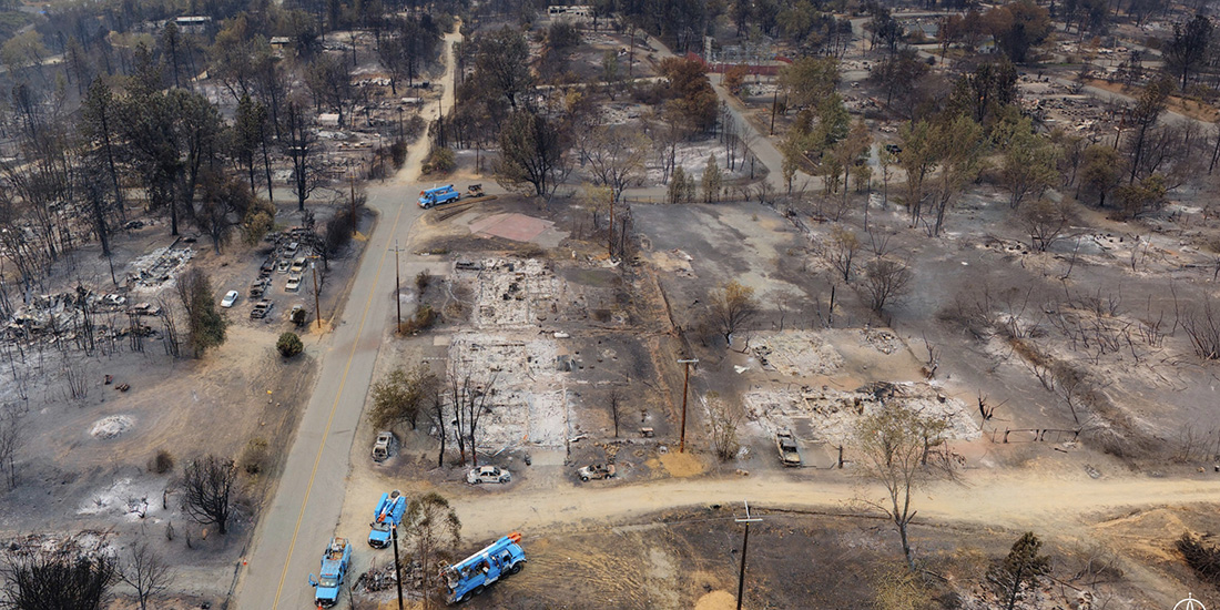
Fig. 1. Santa Rosa CA Wildfire. This is a HANGAR hi-res snapshot, which on a computer can be manipulated in a 360-degree view and zoomed into specific areas. This also reinforces the devastation and total destruction of almost all ground features which makes it difficult to know what area this involves. Agencies are now combining visual imagery with GIS so the drone imagery can be overlayed on geographic layers such as street centerlines and/or satellite map data to provide geographic location identifiers. Source: Courtesy of Alameda County CA Sheriffs Office (2020).
Drones became instrumental during hurricanes Harvey, Irma, and Maria in 2017, with thousands of successful missions in concert with manned aircraft. The major wildfires in 2018 – like the Camp Fire (California) – reinforced the value of drones by providing critical information for responding agencies, such as direction of fire, hotspots that may have been missed, new fires identification, and major damage assessments. The 2018 volcanic activity in Hawaii further validated the value of drones as they could provide real-time information on fissure activity, lava flows endangering homes, and detection of toxic sulfur dioxide gas released from the volcanic activity. This became paramount to warning and evacuating residents from the volcanic dangers. The Lee County (Alabama) Tornado, which caused a wide path of destruction resulting in 23 deaths, marked one of the first news stories reporting that responders immediately deployed drones to complement ground search. In each of these disasters, drones helped to better serve their respective communities.
In response to COVID-19, drones have been used to monitor and promote social distancing, provide public information, spray disinfectant, and even to monitor COVID-19 symptoms (cough, temperature, etc.). Although these flights were well intended, they were not always successful and, in some cases, were rebuked by citizens. One example was in Connecticut, where a drone was proposed to fly around areas and monitor and detect people that displayed symptoms of COVID-19. The community collectively stopped this because they felt that it was too invasive and an intrusion to their individual privacy. This scenario reinforces that drone missions should be selected when they are the best method to achieve the desired outcome and not to use the drone just because it is available.
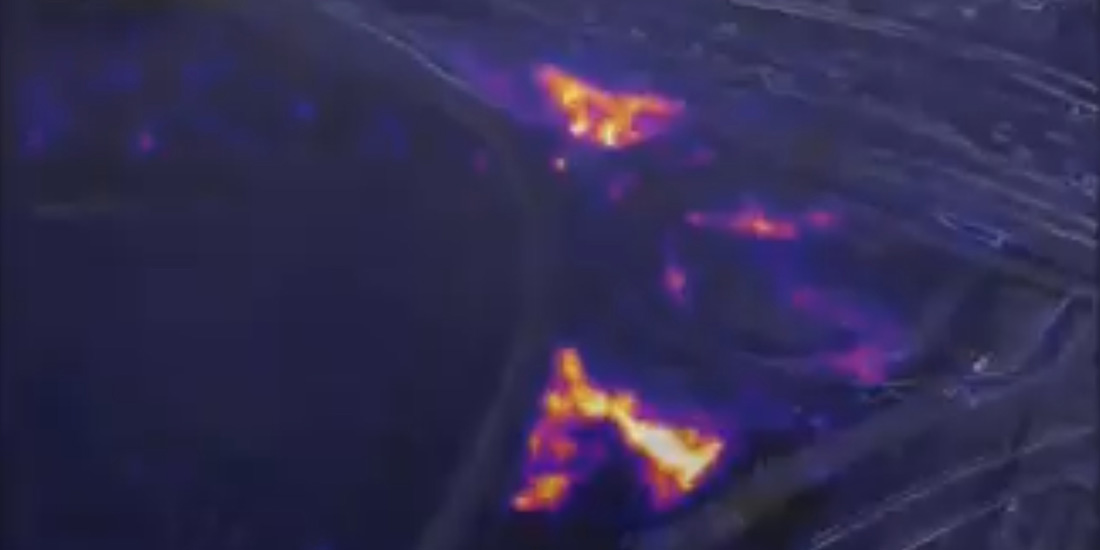
Fig. 2. Colorado Brush Fire. Source: Courtesy Los Angeles City Fire Department (2020).
Growing Demand
Another result noted in the study was that, as the mission types and actual mission requests increase, there is a need for more remote pilots, additional aircraft, and more training. Also revealed was that, if one agency is flying drones, they will see requests from other agencies for missions that may be beyond the initial scope of mission types.
The popularity of drones for disaster response, humanitarian missions, and public safety is very much global and present in over 40 countries. Drone programs are now present in the United States, Canada, South America, the United Kingdom, France, Croatia, Australia, New Zealand, Japan, China, Africa, Saudi Arabia, Scotland, Ireland, Germany, Belgium, to name a few. The main reasons for the popularity of public safety drones are:
- Enhance civilian and responder safety
- Improve operational effectiveness
- Provide real-time situational awareness – “How Bad is Bad?”
- Help to monitor and gauge recovery status/progress
As the global proliferation of public safety drone programs and drones for good continues, it is important to set some ground rules to maintain public trust. To address this issue DRONERESPONDERS, in collaboration with Skydio, published the “Five C’s – Principles on the Responsible Use of Public Safety Drones.” Although the Principles document is focused on the United States, the general principles are applicable to public safety agencies around the world. Drones are clearly making a huge difference and are here to stay.

Charles L. Werner
Charles Werner is a 46-year public safety veteran. He served 37 years with the Charlottesville Fire Department, the last ten years as fire chief. Most recently, he served as senior advisor and acting deputy state coordinator for the Virginia Department of Emergency Management. He has also served in numerous national leadership roles on public safety technology, communications, broadband, applications and devices. Presently, he serves as director, DRONERESPONDERS Public Safety Alliance, chair of the National Council on Public Safety Unmanned Aircraft Systems, chair of the Secure Virginia Unmanned Aircraft Systems Sub Panel, member of the Virginia CIT Unmanned Systems Advisory Board, the National Information Sharing Consortium Advisory Council, the Association of American Railroads Public Safety Rail Advisory Committee and the International Fire Chiefs Technology Council.
- Charles L. Wernerhttps://domesticpreparedness.com/author/charles-l-werner
- Charles L. Wernerhttps://domesticpreparedness.com/author/charles-l-werner
- Charles L. Wernerhttps://domesticpreparedness.com/author/charles-l-werner
- Charles L. Wernerhttps://domesticpreparedness.com/author/charles-l-werner


