Every hurricane season, local and state emergency managers promote preparedness to residents in coastal areas that are at risk—based on whether their residence is located on a 100-year flood map and in an evacuation zone—to ensure that they are aware of their home’s likelihood of being underwater during a storm. High winds cause damage to buildings, homes, and cars, and can result in loss of life and injury. There are actions that can be taken before, during, and after an evacuation to prepare for disasters or emergencies. However, evacuation safety is key, as the majority of deaths caused by hurricanes in the southeastern and northeastern U.S. are due to flooding, resulting in drowning deaths in cars, houses, trailers, or outdoors. Of those who die in hurricanes due to indirect causes, 15% are evacuation-related.
Data from the National Hurricane Center indicate changing trends in direct causes of death. Direct causes of fatalities 1963–2012 have shifted away from storm surge (49%) and freshwater or rainfall flooding (27%). A new analysis suggests that about 57% of deaths following hurricane landfall 2013–2022 were due to freshwater drowning, while deaths from storm surge or wind-related events accounted for only 11% and 12% of deaths, respectively.
In such storms, rapid communication before and during evacuation may reduce the number of deaths and injuries. However, forecasting is still an evolving science. Resiliency planning by emergency managers should include educating the community on the evacuation process, communicating messages to warn people of the path of the hurricane, and coordinating transportation out of the impacted area. The use of early-warning systems, data visualization tools, and communication about shelters, evacuation routes, and open fueling stations can reduce danger and allow people to evacuate before a hurricane makes landfall.
Decision to Evacuate
People residing in coastal areas often experience “hurricane amnesia” and need to be reminded of the potential risks they face. When to evacuate is key, as tropical storms often spin up before meteorologist models can predict the actual timing of landfall. Predictions become more precise within 72 hours of landfall. However, this makes any evacuation plan difficult to implement when trying to safely move people to shelters.
When an evacuation order has been issued for residents living near bodies of water (e.g., ocean, streams, rivers, and other low-lying areas), they should leave immediately and bring with them enough food, water, medication, and other supplies to last a few days. If there is time before leaving the house, they can take precautions (e.g., seal all doors, disconnect all appliances, shut off electricity, and close the main gas valve) and move valuable items to an attic or higher-level floor.
Determine Where to Evacuate
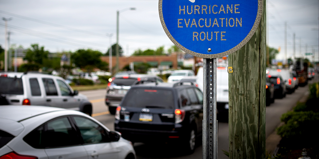
In a hurry, residents may struggle to decide where to go when they need to evacuate their homes. Each family should create an evacuation plan and pick a meeting spot in case family members are separated. Leave a note telling others when you left and where you are going if you don’t have access to the Internet or cell towers. Before or during an evacuation, identify a designated out-of-state friend or relative to drive to. Having a prearranged place to go is helpful, but if the roadways are blocked, a plan may need to be modified to drive to a shelter or hotel. If cell phone power is lost, interruptions may interfere with navigation to reach a planned destination. Knowledge of where nearby community shelters are can prevent delayed arrival to safety. Having an extra container of gas or diesel and cash on hand provides access to gas, food, and lodging if credit card transactions do not work.
In the case of a regional multi-state hurricane, emergency managers may want to work with the department of transportation and other local agencies to determine likely evacuation routes and implement contra-flow shut-offs at highway exits where a lack of infrastructure for medical support, shelter, fuel, or food exists. In some cases, emergency managers may consider a time-phased evacuation approach for counties estimated to experience inland flooding or coastal storm surge instead of issuing a mass evacuation order. It is important to find ways to reduce the number of evacuees and shorten traveling distances, which could impact evacuation clearance time. Minimizing last-minute decisions to drive to other states would facilitate a simpler return to homes and get the economy open again.
Distribution of Basic Supplies
Basic lifesaving supplies or resources may be depleted along evacuation routes—from departure locations to final destinations. Fuel becomes an issue as people often drive hundreds of miles when evacuating. Evacuees may drain the resources of neighboring states without ample notice to accommodate a large influx of people. Local emergency managers may need to work with businesses, nonprofit entities, and public-private companies to ensure a timely flow of relief goods is available for frontline workers, evacuees, and locals. Delays in the supply chain in impacted areas affecting the distribution of basic necessities (e.g., food or water) to shelters, hotels, and temporary housing for evacuees need to be tracked. This ensures that an adequate supply of personal care items (e.g., medication, clothing, diapers) is available until local officials inform residents that roads are free of debris and it is safe to return home. Post-storm, there may be a shortage of cleaning supplies, tarps, and fuel along transportation routes as people return to their homes. Resiliency planners may need to bolster transportation options for disaster relief for hospitals, refrigerated food delivery trucks, debris removal vehicles, and evacuees who need to return home.
Consequences of Delays
The decision to evacuate and retreat 20–50 miles inland may depend on hurricane track projections. Common advice during a hurricane among emergency managers is to “hide from the wind and run from the water.” Evacuees should not travel into the storm’s path, but rather should travel in any direction away from the path of the storm, after assessing hurricane projections. Ideally, one should run from flood waters by evacuating the surge areas to higher ground, or hide from the wind, at home or in a shelter. Delays in evacuation can create life-threatening situations on the route and prevent reaching safety. Accessibility to safe places within the community and of coordinated disaster information and planning services via phone, radio, television, and the internet can help improve life safety among evacuees who may have been stuck in the storm’s path. Although many will debate evacuation planning strategies, evacuees who travel a shorter distance to safety instead of hundreds of miles find themselves safer sooner and closer to home when the storm passes. Monitoring occupant capacity of shelters closest to high-risk areas can help decision-makers throughout the state open more shelters. Evacuees who sheltered closer to home can return home more quickly, allowing businesses to restock at a better time and people to get back to work with less delay.
Improving accessibility to nearby shelters within a community can help improve the timeliness of recovery for disaster survivors. The ability to shelter community members within 10-15 miles of high-impact zones is critical. Resources like the Shelter Field Guide provide a starting point for creating a shelter operations plan. Without the ability to accommodate a large number of people quickly, communities will experience unnecessary deaths related to mass evacuation issues.
Collaboration Is the Goal
Decision-making tools and other real-time storm tracking technology can help emergency managers manage population movement. Prediction models should complement time-phased evacuations and targeted community education events for those living in coastal areas. It is easier to motivate people to evacuate and take shelter 120 hours before hurricane landfall if they do not have to travel far from home or leave their community. When emergency managers and community leaders help residents decide where to go (e.g., reach a shelter or travel north to stay with family or friends or at a hotel), educate them on the process of evacuation (e.g., what to take and how to leave their home safely), and plan for the distribution of basic relief supplies, goods, and equipment while sheltering, people may become less resistant to evacuation.

Judy Kruger
Judy Kruger, Ph.D., is an associate professor at Emory University in the Gangarosa Department of Environmental Health, Rollins School of Public Health. She is a certified business continuity professional (CBCP) and a certified emergency manager with Georgia Emergency Management and Homeland Security (GA CEM). She has responded to several national disasters and is a crisis coach, preparing business and industry leaders for business continuity, disaster response, and recovery. She can be reached at jkruger(a)emory.edu.
- Judy Krugerhttps://domesticpreparedness.com/author/judy-kruger
- Judy Krugerhttps://domesticpreparedness.com/author/judy-kruger
- Judy Krugerhttps://domesticpreparedness.com/author/judy-kruger
- Judy Krugerhttps://domesticpreparedness.com/author/judy-kruger